What are Clouds?
- A cloud is a gathering or aggregation of tiny water droplets and ice crystals suspended in the atmosphere.
- They are huge masses with tremendous density and volume, making them visible to the naked eye. Clouds come in many shapes and sizes.
- They vary in size, shape, and color from one another.
- They play numerous roles in the climate system, including being bright objects in the visible part of the solar spectrum that efficiently reflect light to space, so assisting in planet cooling.
- When the air becomes saturated with water vapor, clouds form.
- Warmer air contains more water vapor than colder air.
- Because these clouds are made of damp air, they get foggy as the air cools significantly.
- As the water vapor and ice particles in these clouds get larger, they fall to the ground as rain, drizzle, snowfall, sleet, or hail.
Formation of Clouds
- Clouds exist because there is water in the sky; clouds form as water evaporates from the ground. Water vapor may not be visible, but it is always there in some form in the sky.
- Clouds occur when the air at a certain region cools to the degree where water vapor condenses into liquid.
- Water condenses when it comes into touch with dust, ice, or salt.
FACTORS LEADING TO CLOUD FORMATION
- Surface Heating: As the sun heats the Earth’s surface, the air in direct contact with it warms and rises. These rising air columns, also known as thermals, contribute to the formation of cumulus clouds.
- Topography, also known as orographic forcing, is the influence of topographical characteristics such as mountains or hills on cloud formation. When air is forced to climb above geographic barriers, it cools as it ascends, resulting in layered clouds.
- Frontal Systems: Clouds arise when warm air rises above a mass of cold, dense air along frontal borders. These fronts mark the transition between warm, wet air and cooler, drier air, resulting in a variety of cloud shapes.
- Convergence: Airstreams coming from different directions collide, forcing the air to climb where they meet. This convergence might result in cumulus clouds and showers.
- Turbulence: Sudden fluctuations in wind speed at different altitudes can cause turbulent eddies in the air, which influences cloud formation.
Importance of Cloud
- Clouds and the Water Cycle: Clouds are similar to how water moves through the environment. They assist in processes such as evaporation, condensation, and precipitation, which are processes that return water to the earth from mist. Thus, they maintain the water balance on Earth.
- Clouds and Weather: Clouds serve as sky indicators of the current weather. We can get clues about the upcoming weather from the different kinds of clouds. For instance, some clouds indicate that it may rain, while others indicate that there will be bright skies. Clouds are used by meteorologists, who study the weather, to assist forecast future events.
- Climate and Clouds: Clouds have a significant role in regulating Earth’s temperature. They function similarly to both a blanket and a natural air conditioner. They retain some heat, like a cozy blanket, and reflect sunlight away, which cools things down. Alterations in cloud cover or quantity can have a direct impact on global temperature, increasing or decreasing.
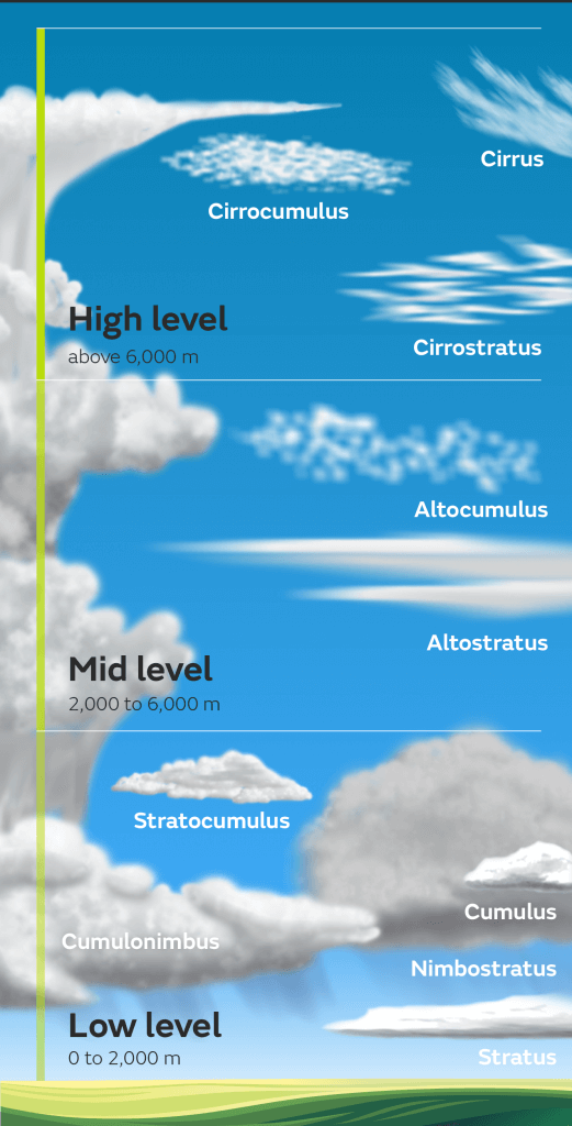
Different types of clouds
| Classification of clouds | Types of clouds |
| High clouds | Cirrus, Cirrostratus, Cirrocumulus |
| Middle clouds | Altostratus, Altocumulus |
| Low clouds | Stratocumulus, Nimbostratus |
| Clouds with extensive vertical development | Cumulus, Cumulonimbus |
- Cirrus clouds are distinct, disconnected cloud formations distinguished by fine, white filaments that appear as patches or thin bands.
- They frequently have a fibrous or silky shine, with a transparent appearance due to the separation of their ice crystals.
- Cirrus clouds, which are made up entirely of ice crystals, rarely dim the sun’s brightness when they pass in front of it.
- However, excessively thick Cirrus clouds can block the sun’s light and outline.
- Cirrus clouds turn vivid yellow or crimson before dawn or after sunset.
- These clouds are typically lighted earlier than other cloud kinds, remaining visible long after sunset and eventually turning grey.
- Cirrus clouds appear yellowish near the horizon due to the increased distance and thickness of air traveled by light rays.
CIRROSTRATUS
- Cirrostratus clouds are distinguished by their translucent, whitish appearance, which resembles a veil with a fibrous or smooth texture.
- These large sheets of clouds finally blanket the entire sky.
- The halo phenomenon caused by the sun or moon can help distinguish between a milky veil of fog or a thin stratus cloud and cirrostratus.
- Cirrostratus clouds frequently produce halos around the sun or moon, distinguishing them from other similar-looking cloud forms.
- A halo effect is frequently associated with cirrostratus clouds.
CIRROCUMULUS
- Usually thin, white patches, sheets, or layers in the sky, cercocumulus clouds don’t usually produce shadows.
- They are made up of tiny components that can resemble ripples or grains grouped in a regular pattern.
ALTOSTRATUS
- Altostratus clouds frequently show up in the sky as gray or bluish sheets or layers.
- They tend to blanket the sky partially or entirely and can be striated or fibrous.
- It appears as though you are looking at the sun through ground glass because these clouds are thin enough to let some sunlight through.
- They don’t create a halo around the sun or moon like cirrostratus clouds do, and they also block the view of ground-level object shadows.
- Typically, altostratus clouds are located in the middle layers of the atmosphere.
ALTOCUMULUS
- The kind of cloud you are referring about is an altocumulus cloud.
- Typically, altocumulus clouds show up as layers, sheets, or patches of white or grey sky.
- They may consist of rolls, spherical masses, or laminae (plates), and their margins may be scattered or fibrous.
- The capacity of altocumulus clouds to produce the vivid optical phenomenon known as a corona is one of their defining characteristics.
- A corona, or colored ring or halo, is seen when a thin, semi-transparent segment of altocumulus clouds passes in front of the sun or moon.
- This optical phenomenon consists of a ring that is blue in the center and red on the periphery. When such clouds are present, coronas usually occur within a few degrees of the sun or moon.
NIMBOSTRATUS
- Thinning Altostratus clouds give rise to continuous rain clouds, or nimbolostratus clouds.
- These clouds frequently take the form of a dense, dark grey layer that is diluted by snow or rain.
- Usually, they are thick enough to totally block out the sun.
- As precipitation persists, nimboltus clouds descend from higher elevations and progressively combine with low-level clouds.
- They frequently bring long stretches of consistent rain, which makes the weather dreary and overcast.
STRATOCUMULUS
- Usually having a grey or whitish hue, stratocumulus clouds can be seen as layers, sheets, or patches.
- They frequently have black tessellations, which can take the shape of spherical masses or rolls and have a mottled or honeycomb look.
- The only fibrous ingredient typically present in these clouds is virga, or precipitation that evaporates before it reaches the ground.
- Stratocumulus clouds are typically seen at lower to moderate altitudes and can merge or not.
STRATUS
- When stratus clouds are deep enough, they can produce snow grains, ice prisms, or drizzle in addition to their usual uniform, grey cloud cover.
- This kind of cloud allows for the sun’s shape to be seen through it, indicating a diffuse transmission of light.
- There may be blue sky patches exposed as stratus clouds break up or disperse, creating a striking contrast between the remaining cloud cover and the clear parts.
- This kind of cloud frequently forms at low altitudes and tends to produce cloudy or dreary weather.
CUMULUS
- These clouds appear as isolated, thick formations that typically have a clear vertical development. They can take the form of rising mounds, domes, or towers that frequently have protruding upper portions that resemble cauliflowers.
- These clouds are frequently bright white in the sunlight areas and appear comparatively dark with a horizontal orientation at their bases.
CUMULONIMBUS
- The cloud being described is a thunderstorm cloud, often known as a Cumulonimbus cloud.
- These clouds have the weight and density of a mountain or other tall building.
- Their upper parts frequently have a flattened, anvil-like or plume-like shape and are smoother, fibrous, or striated in appearance.
- The bases of cumulonimbus clouds are sometimes quite dark, and they are often accompanied by low, ragged clouds that may or may not blend with the base.
- In addition to being notorious for producing hail, these clouds are frequently linked to tornadoes, resulting in severe and turbulent weather.