- Ocean currents are consistent, directional movements of seawater, driven and influenced by various forces, akin to massive river flows within the oceans.
- Ocean currents are like river flow in oceans. They represent a regular volume of water in a definite path and direction.
- These movements occur in two main directions: horizontally and vertically.
- Horizontal movements, termed as currents, span across vast distances within the oceans.
- Vertical changes, known as upwellings or downwellings, involve the movement of water in a vertical direction.
- The influence of ocean currents extends beyond the marine environment, significantly impacting climate patterns and thereby affecting humankind and the biosphere.
- Ocean currents are influenced by two types of forces namely:
- primary forces that initiate the movement of water;
- secondary forces that influence the currents to flow
- The primary forces that influence the currents are:
- heating by solar energy;
- wind;
- gravity;
- Coriolis force.
- The secondary forces that influence the currents are:
- Temperature difference;
- Salinity difference
Primary Forces Responsible for Ocean Currents
Influence of insolation
- Solar energy heating causes water molecules to expand, contributing to the rise in sea levels.
- In regions close to the equator, ocean water levels are approximately 8 cm higher compared to areas at middle latitudes.
- Gravity acts to mitigate these differences by exerting force on the water, pulling it down along the gradient and helping to maintain equilibrium.
Influence of wind (atmospheric circulation)
- The wind’s frictional force on the ocean’s surface drags the water, influencing the movement of ocean currents.
- Winds play a dual role in determining both the strength and direction of ocean currents, with the Coriolis force affecting their direction.
- For instance, monsoon winds in the Indian Ocean lead to seasonal changes in ocean currents.
- Generally, the global pattern of oceanic circulation mirrors that of atmospheric circulation on Earth.
- In middle latitudes, where air circulation over oceans is predominantly anticyclonic, corresponding oceanic circulation follows suit.
- Conversely, at higher latitudes where wind flow is primarily cyclonic, oceanic circulation patterns align with this atmospheric pattern.
Influence of Coriolis force
- The Coriolis force deflects ocean water to the right in the Northern Hemisphere and to the left in the Southern Hemisphere, influencing the direction of ocean currents.
- These deflected currents accumulate to form large circular patterns known as gyres, which are prevalent in all ocean basins.
- Gyres generate expansive circular currents within the ocean, with one notable example being the Sargasso Sea.
Secondary Forces Responsible for Ocean Currents
- Temperature difference and salinity difference are the secondary forces. They create density differences.
- Differences in water density affect vertical mobility of ocean currents (vertical currents).
- Water with high salinity is denser than water with low salinity.
- Similarly, cold water is denser than warm water.
- Denser water tends to sink, while relatively lighter water tends to rise.
Types of Ocean Currents
Based on depth the ocean currents may be classified as
Surface currents:
- Large-scale surface ocean currents are driven by global wind systems that are fueled by energy from the sun.
- These currents transfer heat from the tropics to the polar regions, influencing local and global climate.
- It constitute about 10% of all the water in the ocean, these waters are the upper 400 m of the ocean.
Deep water currents:
- It makes up the other 90% of the ocean water.
- These waters move around the ocean basins due to variations in the density and gravity.
- Deep waters sink into the deep ocean basins at high latitudes, where the temperatures are cold enough to cause the density to increase.
- This starts’ the global conveyor belt, a connected system of deep and surface currents that circulate around the globe on a 1000 year time span.
- This global set of ocean currents is a critical part of Earth’s climate system as well as the ocean nutrient and carbon dioxide cycles.
- Differences in water density, resulting from the variability of water temperature (thermo) and salinity (haline), also cause ocean currents. This process is known as thermohaline circulation.
Based on temperature ocean currents are classified as
Cold-water ocean currents
These currents occurs when the cold water at the poles sinks and slowly moves towards the equator as subsurface flow. Cold currents are usually found on the west coast of the continents (because of clockwise flow in northern hemisphere and anti-clockwise flow in southern hemisphere) in the low and middle latitudes (true in both hemispheres) and on the east coast in the higher latitudes in the Northern Hemisphere.
Warm-water currents
These currents travel out from the equator along the surface, flowing towards the poles to replace the sinking cold water. Warm currents are usually observed on the east coast of continents in the low and middle latitudes (true in both hemispheres). In the northern hemisphere, they are found on the west coasts of continents in high latitudes.
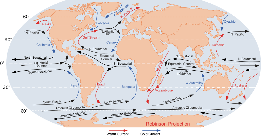
Pacific Ocean Currents
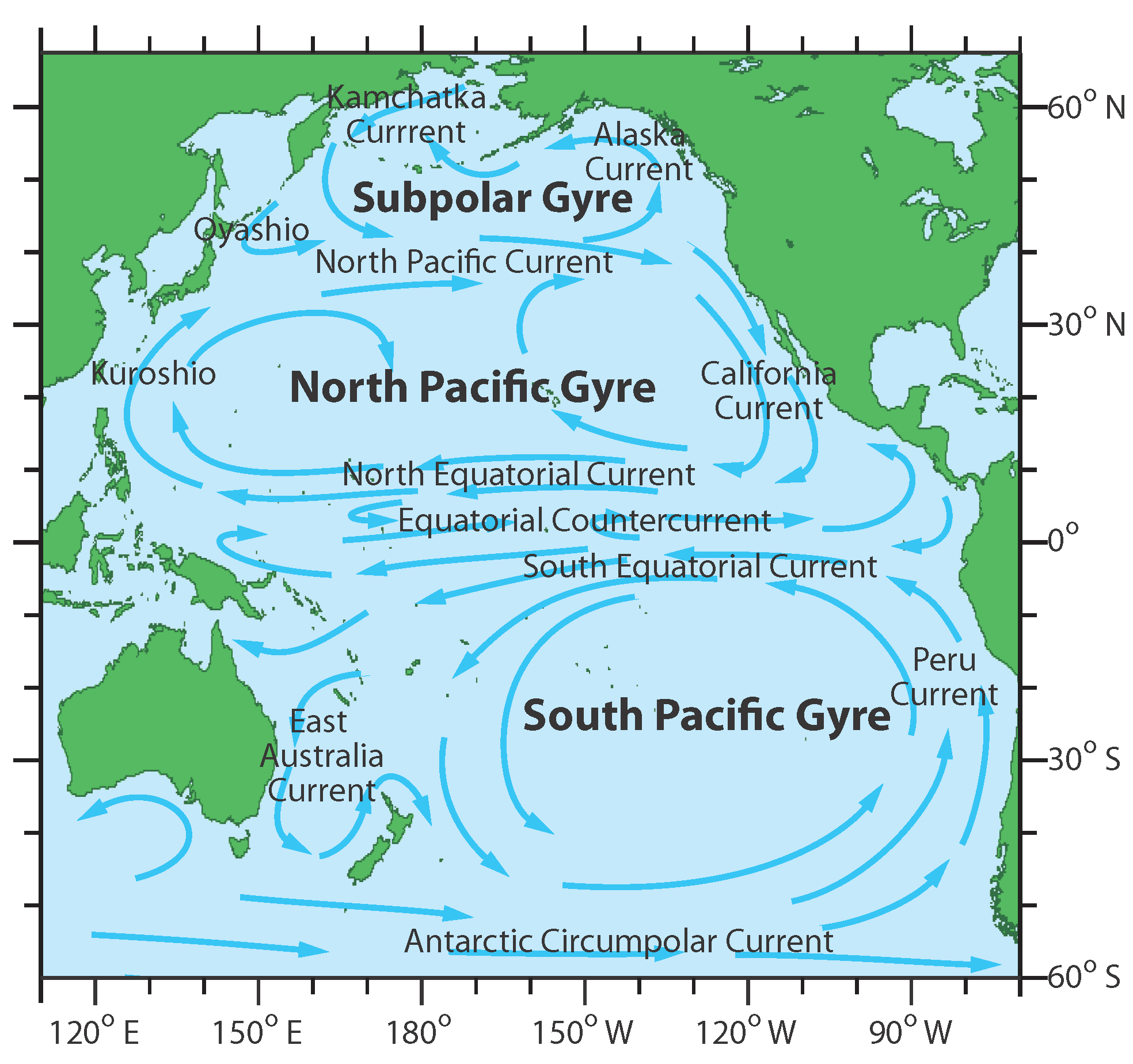
Equatorial currents – warm
- Prevailing trade winds, known as tropical easterlies, initiate the movement of two major currents: the north equatorial current and the south equatorial current. These currents originate from the eastern Pacific, specifically the west coast of Central America.
- Spanning a vast distance of 14,500 kilometers, these currents travel in an east to west direction across the Pacific Ocean.
- The westward movement of these currents results in the elevation of the ocean level in the western Pacific region, particularly near Indonesia and Australia, by a few centimeters.
- This elevation creates a counter-equatorial current, which flows horizontally between the north and south equatorial currents, moving from west to east.
- Factors that aid the formation of Counter-Equatorial current
- Piling up of water in the western Pacific due to trade winds.
- The presence of doldrums (calm region in equatorial low-pressure belt) in between the north equatorial current and the south equatorial current.
Kuroshio current – warm
- The north equatorial current turns northward off the Philippines to form the Kuroshio current.
- It flows in the sub-tropical high-pressure belt, and its northern part is under the influence of westerlies
Oyashio Current and Okhotsk current – cold
- The Oyashio current courses along the eastern coast of the Kamchatka Peninsula before blending with the warmer waters of the Kuroshio.
- Meanwhile, the Okhotsk current travels past the Sakhalin Islands and eventually meets the Oyashio current near Hokkaido, a northern Japanese island.
- This convergence between the cold Oyashio and the warmer currents creates a dynamic zone renowned for its abundant marine life, establishing it as one of the most fertile fishing regions globally.
North-Pacific current – warm
- From the south-east coast of Japan, under the influence of prevailing westerlies, the Kuroshio current turns eastwards and moves as the North-Pacific current, reaches the west coast of North America, and bifurcates into two.
Alaska current – warm
- The northern branch of the North Pacific current follows a counterclockwise trajectory along the coastlines of British Columbia and Alaska, earning the name Alaska current.
- Notably, the waters within this current maintain a relatively warmer temperature compared to the surrounding regions in this area.
Californian current – cold
- The southern branch of the North Pacific current flows southward along the western coast of the USA, characterized by its cold temperatures and recognized as the Californian current.
- This current eventually converges with the north equatorial current, forming a complete circuit of oceanic circulation.
East Australian current – warm
- Mimicking its northern hemisphere counterpart, the south equatorial current moves in an east to west direction before veering southward, transforming into the East Australian current.
- Upon its southward trajectory, it encounters the westward-flowing South Pacific current near Tasmania, completing a vital intersection of oceanic currents in the region.
Peru current or Humboldt Current – cold
- Upon reaching the southwestern coast of South America, the South Pacific current alters its course, heading northward and assuming the name Peru current.
- This current is characterized by its cold temperatures and plays a crucial role in replenishing the south equatorial current, ultimately closing the loop of the grand oceanic circuit.
- The convergence point where the chilly Peru current intersects with the warmer waters of the equatorial region forms a significant fishing zone, renowned for its rich marine biodiversity.
Atlantic Ocean Currents
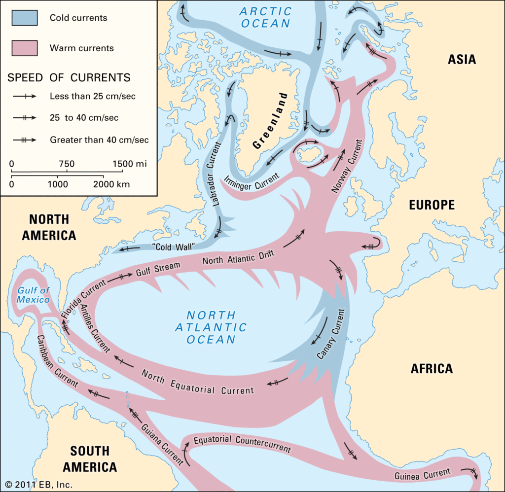
Equatorial Atlantic Ocean Currents – warm
- Guided by the prevailing easterly trade winds, both the north and south equatorial currents originate from the eastern Atlantic, specifically the west coast of Africa, and traverse westward.
- As these currents progress, they cause a slight elevation in the water level of the western Atlantic, particularly north of the Brazil bulge, by a few centimeters.
- This elevation instigates the formation of a counter-equatorial current, flowing horizontally between the north and south equatorial currents in an east to west direction.
Antilles current – warm
- Near Cape de Sao Roque in Brazil, the south equatorial current divides into two distinct branches.
- One branch merges with the north equatorial current, entering the Caribbean Sea and eventually reaching the Gulf of Mexico.
- Meanwhile, the other branch follows the eastern periphery of the West Indies as the Antilles current.
- Notably, the influx of substantial water volumes from the Mississippi River, as well as contributions from both the north and south equatorial currents, leads to a rise in water levels within the Gulf of Mexico.
Gulf Stream and North Atlantic Drift – warm
- The Antilles current generates a flow that exits through the Strait of Florida, forming the Florida current, which later merges with the southern Antilles current.
- This unified current travels along the eastern coast of the USA, initially identified as the Florida current until it reaches Cape Hatteras.
- Beyond Cape Hatteras, it transforms into the renowned Gulf Stream.
- Upon nearing the Grand Banks, the Gulf Stream intermingles with the cold Labrador and East Greenland currents.
- The amalgamation then proceeds eastward across the Atlantic as the North Atlantic Drift.
- The westerly motion observed in the North Atlantic Drift is driven by the influence of westerly winds.
Norwegian current – warm
- Upon reaching the eastern part of the ocean, the North Atlantic Current diverges into two distinct branches.
- The primary branch, known as the North Atlantic Drift, continues its journey toward the British Isles and then follows the coastline of Norway as the Norwegian Current, ultimately venturing into the Arctic Ocean.
- The Norwegian Current plays a crucial role in maintaining ice-free conditions in the northern seas of Norway, thus tempering the region’s climate.
- Thanks to the moderating influence of this current, Russia can transport cargo through the Arctic Ocean via the Barents Sea during the summer months.
- The southern branch of the current travels between Spain and the Azores, manifesting as the chilly Canary Current.
- Eventually, this branch merges with the north equatorial current, thus completing its cycle within the North Atlantic region.
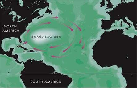
- Nestled within this circuit lies the Sargasso Sea, characterized by abundant seaweed, rendering it a significant geographical entity.
Sargasso Sea – a sea without a land boundary
- Positioned at the heart of the North Atlantic Ocean’s gyre, the Sargasso Sea stands out as a distinct region.
- It holds the unique distinction of being the sole sea on our planet devoid of any coastline.
- Bounded by significant currents on all sides:
- To the west, it is embraced by the warm Gulf Stream.
- In the north, it meets the flow of the North Atlantic Current.
- Its eastern boundary is defined by the cool waters of the Canary Current.
- To the south, it is encircled by the North Atlantic Equatorial Current.
- The convergence of these currents establishes the framework for the North Atlantic Gyre.
- Consequently, the Sargasso Sea becomes the ultimate repository for the marine vegetation transported by these currents.
Brazil current – warm
- Within the South Atlantic Ocean, the south equatorial current, coursing from east to west, bifurcates near Cape de Sao Roque, Brazil.
- One segment of this current heads northward to merge with the north equatorial current, with a portion also diverging into the Antilles Current and another segment streaming into the Gulf of Mexico.
- Meanwhile, the southern branch veers southward, tracing the contours of the South American coastline as the balmy Brazil Current.
- As it progresses, the Brazil Current alters its course eastward around latitude 35°S, influenced by the prevailing westerly winds, ultimately converging with the West Wind Drift, which flows from west to east.
- A minor offshoot of the West Wind Drift forks off and travels between the Argentinian coast and the Falkland Islands, recognized as the Falkland Cold Current.
- This current intermingles with the warmth of the Brazil Current upon reaching the southernmost point of Brazil.
Benguela current – cold current
- A branch of the South Atlantic splits at the southern tip of Africa and flows along the west coast of South Africa as the cold Benguela current, which joins the south equatorial current to complete the circuit
Indian Ocean Currents
North Indian Ocean Currents
- The currents in the northern portion of the Indian Ocean change their direction from season to season in response to the seasonal rhythm of the monsoons.
- The effect of winds is comparatively more pronounced in the Indian Ocean.
Winter Circulation
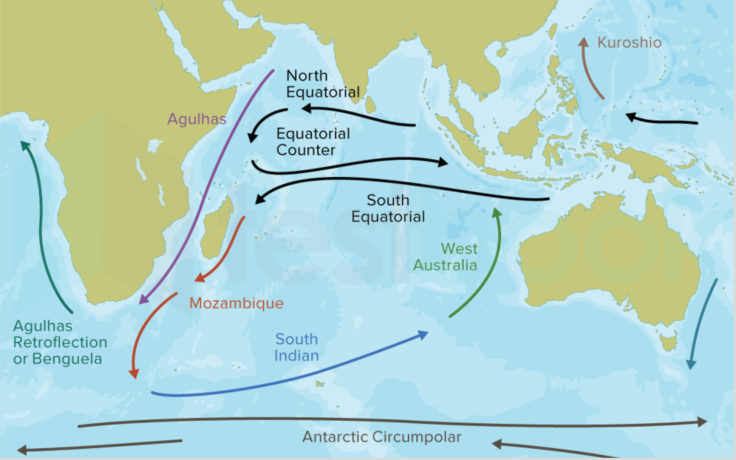
- Under the influence of prevailing trade winds, the north equatorial current and the south equatorial current start from the south of Indonesian islands, moving from east to west.
- This raises the level of western Indian (south-east of horn of Africa) ocean by few centimetres.
- And this creates a counter-equatorial current which flows between the north equatorial current and the south equatorial current in west-east direction.
- The north-east monsoons drive the water along the coast of Bay of Bengal to circulate in an anticlockwise
direction. - Similarly, the water along the coast of Arabian Sea also circulate in an anti-clockwise circulation.
Summer Circulation
- During the summer months, the powerful influence of the southwest monsoon and the absence of the northeast trade winds lead to the emergence of a robust west-to-east current.
- This prevailing current effectively overrides the north equatorial current, rendering it virtually non-existent.
- Consequently, the absence of a counter-equatorial current further reinforces this pattern.
- As a result, the water circulation dynamics in the northern region of the ocean adopt a clockwise direction throughout this season.
Southern Indian Ocean Currents
- The circulation dynamics in the southern part of the Indian Ocean closely resemble those observed in the southern Atlantic and Pacific Oceans, with less pronounced seasonal variations.
- Originating partly from the Pacific Ocean, the south equatorial current maintains its east-to-west flow.
- Upon reaching the vicinity of Madagascar, this current divides into two branches:
- One branch courses to the east of Madagascar, recognized as the Agulhas Current.
- The other branch travels between Mozambique and the western coast of Madagascar, termed the Mozambique Current.
- These two branches converge at the southern tip of Madagascar, amalgamating into what is commonly referred to as the Agulhas Current, retaining its warm character until its confluence with the West Wind Drift.
- Meanwhile, the West Wind Drift, spanning the higher latitudes and flowing from west to east across the ocean, extends to the southern tip of the west coast of Australia.
- A segment of this cold current veers northward along the west coast of Australia, forming the West Australian Current, which then proceeds northward to replenish the south equatorial current.
Arctic Ocean Currents
East Greenland Current
- The East Greenland Current (EGC) is a cold and low-salinity current spanning from Fram Strait (~80N) to Cape Farewell (~60N).
- It aligns with the eastern coast of Greenland along the Greenland continental margin.
- The EGC traverses through the Nordic Seas, including the Greenland and Norwegian Seas, and passes through the Denmark Strait.
- Its significance lies in its direct connection between the Arctic and the Northern Atlantic.
- As a major contributor, the EGC facilitates the export of sea ice out of the Arctic.
- Additionally, it acts as a substantial freshwater sink for the Arctic region.
East Iceland Current (EIC)
- The East Iceland Current (EIC) is a cold water ocean current originating east of Greenland at coordinates 72°N, 11°W.
- It branches off from the East Greenland Current and merges with the southward-flowing Irminger Current.
- Upon reaching the northeast part of Iceland, the EIC swiftly rotates counterclockwise and begins to flow eastward along the Iceland-Faeroe Ridge.
- Subsequently, it veers northward and continues its course into the Norwegian Sea.
- The EIC maintains an average flow rate of 6 centimeters per second, with its maximum velocity of 10 centimeters per second observed as it transitions to an eastward direction.
Labrador Current
- The Labrador Current is a chilly oceanic current situated in the North Atlantic Ocean.
- Originating from the Arctic Ocean, it journeys southward along the coast of Labrador.
- Continuing its path, the current circumnavigates Newfoundland before progressing southward along the eastern coast of Canada near Nova Scotia.
- Close to Nova Scotia, this cold-water current encounters the warm, northward-flowing Gulf Stream.
- The convergence of these contrasting currents gives rise to dense fog formations.
- Additionally, this meeting point fosters the development of exceptionally fertile fishing grounds, rendering it one of the most bountiful fishing regions globally.
Norwegian Current
- The Norwegian Current, also referred to as the Norway Coastal Current, stands as one of the primary inflows of Arctic water.
- Its origins can be traced from near Shetland, north of Scotland, or from the eastern North Sea, reaching depths of up to 100 meters.
- Ultimately, it courses towards the opening into the Barents Sea, a significant extension of the Arctic Ocean.
- In comparison to its partial source, the North Atlantic Current, which may loop into the East Greenland Current, the Norwegian Current exhibits lower temperatures and salinity levels.
- Other contributing sources include the relatively less saline North and Baltic Seas, as well as the Norwegian fjords and rivers.
- Despite its colder and less salty nature compared to the North Atlantic Current, the Norwegian Current remains notably warmer and saltier than the Arctic Ocean itself, which undergoes freshening due to precipitation and ice accumulation within and surrounding its boundaries.
West Spitsbergen Current (WSC)
- The West Spitsbergen Current (WSC) is a significant warm and salty current coursing poleward just west of Spitsbergen in the Arctic Ocean.
- Originating as a branch of the Norwegian Atlantic Current within the Norwegian Sea, the WSC plays a crucial role in transporting warm and saline Atlantic Water into the heart of the Arctic.
- Its influence is paramount as it propels this warm and saline current northward through the eastern side of Fram Strait.
- In contrast, the East Greenland Current (EGC) flows southward through the western side of Fram Strait.
- Thus, the WSC serves as a vital conduit for the infusion of warmth and salinity into the interior regions of the Arctic, contributing significantly to its oceanic dynamics.