Mountain Pass
A mountain pass is a narrow gap or route through a mountain range or ridge that allows for passage from one side to the other. At lower elevations it may be called a hill pass. Mountain passes have played a crucial role throughout history as natural corridors for transportation, trade, and military movements. Mountain passes serve as important geographic features that influence human activities, economic development, and environmental dynamics in mountainous regions.
Importance of Mountain Pass
Mountain passes are crucial geographic features with several important functions:
- Transportation: Mountain passes allows easier transportation of people, goods, and information. Historically, they facilitated trade routes, military movements, and migration.
- Connectivity: Passes connect different regions, cultures, and economies, fostering exchange and interaction between communities that might otherwise be isolated.
- Trade and Commerce: Passes have long been vital for trade, enabling merchants to transport goods across mountainous terrain.
- Military Significance: Throughout history, controlling mountain passes has been strategically important for military purposes. Passes can offer defensive advantages or serve as invasion routes, shaping the outcomes of conflicts.
- Tourism and Recreation: Many mountain passes are renowned for their scenic beauty and recreational opportunities. They attract tourists, hikers, climbers, and other outdoor enthusiasts, contributing to local economies through tourism.
- Ecological Connectivity: Mountain passes can serve as corridors for wildlife, allowing species to migrate and maintain genetic diversity.
- Water Resources: Some mountain passes serve as watersheds, directing the flow of water from one side of the range to the other.
- Cultural and Historical Significance: Many passes have cultural or historical significance, often serving as pilgrimage routes or featuring in folklore and legends.
Major Passes on Map
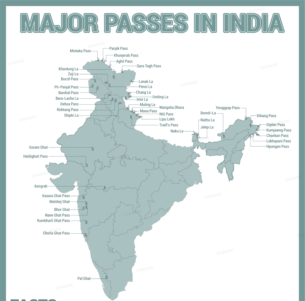
Major Mountain Passes in Leh-Ladakh
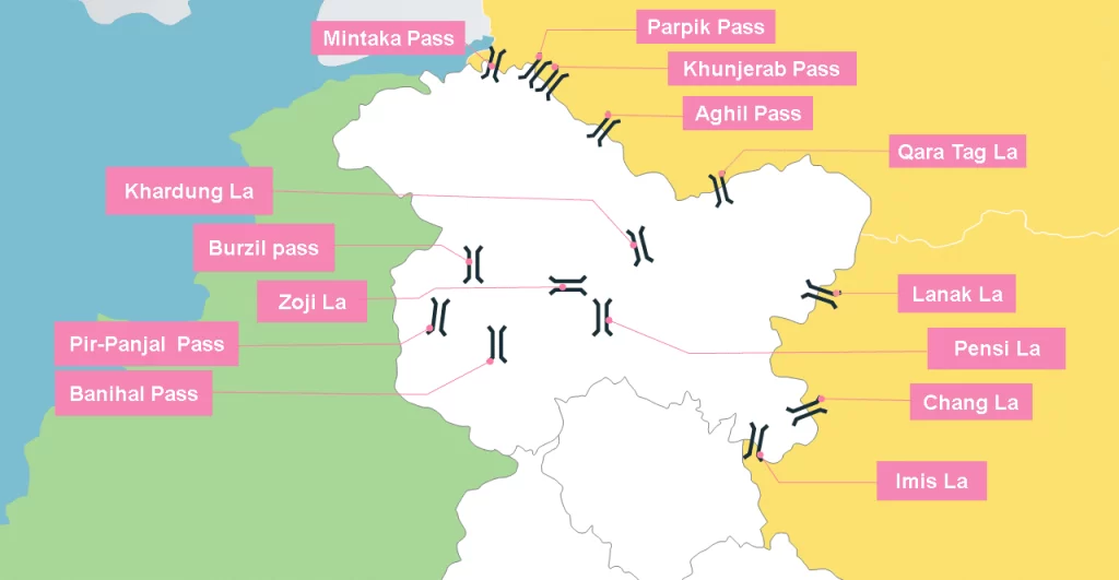
| Mountain Pass | Description |
|---|---|
| Aghil Pass | The mountain pass separates the Ladakh region in India with the Shaksgam Valley in China. The mountain pass lies in the transition between the valley of the Yarkand River and the valley of the Shaksgam River. The mountain pass is inaccessible during the winter season between November and May. |
| Bilafond La | Bilafond La (meaning “Pass of the Butterflies” in Balti language, also known as the Saltoro Pass, is a mountain pass situated on Saltoro Ridge, sitting immediately west of the vast Siachen Glacier, which defined the end of the 1972 Line of Control between Pakistan and India as part of the Simla Agreement.Bilafond La is on the ancient Silk Route linking the Indian Subcontinent and China. |
| Changla Pass | Chang La is a high mountain pass in Ladakh at an elevation of 5,391.3024 m or 17,688.000 ft in the Ladakh Range between Leh and the Shyok River valley. Chang La literally means “Northern Pass”. The world’s highest research station, established by the Defence Research and Development Organisation is functional in Chang La at a height of 17,664 ft. |
| Fotu La | Fotu La or Fatu La is a mountain pass on the Srinagar-Leh highway in the Zanskar Range of the Himalayas in India. There is a Prasar Bharati television relay station serving Lamayuru located on the pass. |
| Imis La | The pass has a difficult geographical terrain and steep slopes. This pass remains closed during the winter season. It connects Ladakh and Tibet. |
| Karakoram Pass (Qara Tagh La) | The Karakoram Pass is mountain pass between India and China in the Karakoram Range. It plays a major geographic role in the dispute between Pakistan and India over control of the Siachen Glacier area immediately to the southwest of the pass. |
| Khardung La | The pass is on the Ladakh Range, north of Leh, and connects the Indus river valley and the Shyok river valley. It also forms the gateway to the Nubra Valley, beyond which lies the Siachen Glacier. It is the highest motorable pass in the country. |
| Kongka Pass | The Kongka Pass or Kongka La is a low mountain pass on the Line of Actual Control between India and China in eastern Ladakh. |
| Lanak Pass | Lanak La had been a well-established frontier point between Ladakh and Tibet. |
| Lungalacha La | Lachulung La (el. 5,059 m or 16,600 ft), or Lāchālūng La or Lungalacha La, is a paved motorable mountain pass in Ladakh in India just north of border with Himachal Pradesh. |
| Marsimik La | The ridge line of Marsimik La divides the basin of the Pangong Lake from the Chang Chenmo River. |
| Namika La | Namika La (“Pillar of the Sky Pass”) is a high mountain pass in the Zaskar Range of the Himalayas in Ladakh, |
| Rezang La | Rezang La is a mountain pass on the Line of Actual Control between Indian-administered Ladakh and the Chinese-administered Spanggur Lake basin. The pass is located on the watershed ridge of the Chushul Valley. |
| Sia La | Sia La is a mountain pass situated on Saltoro Ridge, in Ladakh, India, north-northwest of map point NJ9842 which defined the end of the 1972 Line of Control between India and Pakistan as part of the Simla Agreement. |
| Tanglang La (Thang La) | It is located on the NH3 Leh–Manali Highway. |
| Umling La | Umling La or Umlung La is the highest paved road and mountain pass in the world, located in Ladakh, India on the ridgeline between Koyul Lungpa and the Indus River near Demchok. |
| Zojila Pass | It is in the Kargil district, Indian Union territory of Ladakh. |
Major Mountain Passes in Jammu and Kashmir
| Mountain Pass | Description |
|---|---|
| Banihal Pass | Banihal Pass is a mountain pass across the Pir Panjal Range in India. |
| Gyong La | Gyong La is a mountain pass situated on Saltoro Ridge southwest of the vast Siachen Glacier |
| Pir-Panjal Pass | The Pir Panjal Pass, also called Peer Ki Gali, is a mountain pass and a tourist destination located in the Pir Panjal Range in Jammu and Kashmir, India. It connects the Kashmir Valley to the Rajouri and Poonch districts of Jammu via the Mughal Road. The Pir Panjal Pass appears in Srivara’s Rajatarangini as Panchaladeva |
| Burzail Pass | This pass joins the Astore Valley of Kashmir with the Deosai Plains of Ladakh. |
Major Mountain Passes in Himachal Pradesh
| Mountain Pass | Description |
|---|---|
| Bara-lacha-la | Bara-lacha-la is a high mountain pass in the Zanskar range of Northern-India, connecting Lahaul district in Himachal Pradesh to Leh district in Ladakh. The two headwaters of the Chenab River, Chandra and Bhaga, originate near the Baralacha Pass. |
| Chanshal Pass | The Chanshal Pass, or Chanshal Valley, links Dodra Kwar and Rohru (Chirgaon) in the Shimla district of the Indian state of Himachal Pradesh. |
| Debsa Pass | Debsa Pass is a 5,360-metre-high (17,590 ft) mountain pass in the Himalaya mountains between the Kullu and Spiti Districts of Himachal Pradesh, India. |
| Indrahar Pass | Indrahar Pass is a mountain pass in the Dhauladhar range of the Himalayas. Indrahar pass forms the border between Kangra and Chamba districts. It is part of a very popular trekking route from Dharamshala. |
| Kunzum Pass | Kunzum Pass is a high mountain pass in the eastern Kunzum Range of the Himalayas. It connects Lahaul valley and Spiti valley. |
| Lamkhaga Pass | The Lamkhaga Pass is one of the toughest pass which connects Kinnaur district of Himachal Pradesh with Harshil in Uttarakhand. |
| Rohtang Pass | Rohtang Pass is a high mountain pass (elevation 3,980 m (13,058 ft)) on the eastern end of the Pir Panjal Range of the Himalayas. It connects the Kullu Valley with the Lahaul and Spiti Valleys of Himachal Pradesh, India. |
| Shipki La | The pass is on the border between the Kinnaur district in the state of Himachal Pradesh, India, and the Ngari Prefecture in Tibet, China. |
Major Mountain Passes in Uttarakhand
| Mountain Pass | Description |
|---|---|
| Auden’s Col | Auden’s Col is a high altitude mountain pass connecting Rudugaira valley and Bhilangna valley in India. |
| Kalindi Pass | Kalindi pass, or Kalindi khal is a high altitude mountain pass connecting Gangotri and Ghastoli. |
| Lipulekh Pass | Lipulekh La or Lipulekh Pass is a Himalayan pass in the border between India on the northern border with Tibet region held by China. It is used by pilgrims to Kailas and Manasarovar. |
| Mana Pass | Mana Pass is located within the Nanda Devi Biosphere Reserve, north of the Hindu pilgrimage town of Badrinath in Uttarakhand. It is the source of the Saraswati River. |
| Muling La | Connects Uttarakhand to Tibet. |
| Nama Pass | Nama Pass (el. 5,200 m (17,100 ft)) is a Himalayan mountain pass located in eastern Kumaun region of the Pithoragarh District of Uttarakhand, India. |
| Niti Pass | Niti Valley is a remote valley located in the northernmost region of Uttarakhand, India at a height of 3, 600 m (11, 811 ft). It is close to the Chinese border and Niti is the last village in the valley before the border with south Tibet. The Niti Pass was an ancient trade route between India and Tibet, and it was sealed after the 1962 Sino-Indian War. |
| Sin La | This pass connects Bidang in Darma Valley to Jolingkong Lake in the Kuthi Yankti valley. |
| Traill’s Pass | Pindari Kanda Traill’s Pass (el. 5,300 m or 17,400 ft) is a mountain pass through the Himalayas located between Nanda Devi and Nanda Kot peaks in the Uttarakhand state in the districts of Pithoragarh and Bageshwar in India. It is situated at the end of Pindari glacier. |
Major Mountain Passes in Sikkim
| Mountain Pass | Description |
|---|---|
| Dongkhala | The Dongkha la or Donkia Pass is a high mountain pass in the Himalaya connecting Sikkim in India with Tibet. |
| Goecha La | Goecha La (el. 4940 mt or 16,207 ft) is a high mountain pass in Gyalshing district, Sikkim, India in the Himalaya range. |
| Jelep La | Jelep La is a high mountain pass between Sikkim, India and Tibet Autonomous Region, China. It is on a route that connects Lhasa to India. The Menmecho Lake lies below the Jelep La. |
| Nathu La | Nathu La is a mountain pass in the Dongkya Range of the Himalayas between China’s Yadong County in Tibet, and the Indian states of Sikkim. Nathu La is a mountain pass on the Dongkya Range that separates Sikkim and the Chumbi Valley. |
Major Mountain Passes in Arunachal Pradesh
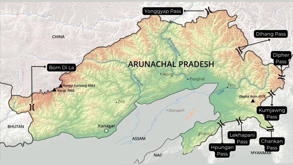
| Mountain Pass | Description |
|---|---|
| Bomdila | The Bomdila is a high mountain pass nestled at the height of 2,608 m above the sea level. The road over the pass is mainly covered. This pass is known as the Road 229 amid Dirang and Tenga on the path to Tawang. |
| Bum La Pass | Bum La Pass is located at an altitude of 5,000 meters (16,500 ft) above sea level in the Tawang district of Arunachal Pradesh. |
| Chankan Pass | This pass connects Arunachal Pradesh with Myanmar. |
| Dihang Pass | It is located in the Northeastern states of Arunachal Pradesh. This pass connects Arunachal Pradesh with Myanmar (Mandalay). |
| Diphu Pass (Dipher Pass) | Diphu Pass is a mountain pass around the area of the disputed tri-point borders of India, China, and Myanmar. Diphu Pass is also a strategic approach to eastern Arunachal Pradesh in India. It lies on the McMahon Line. It is located in Anjaw district of Arunachal Pradesh. |
| Kumjawng Pass | Kumjawng Pass also lies on the Indo-Myanmar border at an altitude of 2929 and joins Arunachal Pradesh with Myanmar. |
| Mayodia Pass | Mayodia Pass, 56 km from Roing in Dibang Valley district of Arunachal Pradesh. |
| Pangsau Pass | Pangsau Pass or Pan Saung Pass, 3,727 feet (1,136 m) in altitude, lies on the crest of the Patkai Hills on the India–Myanmar border. The pass offers one of the easiest routes into Burma from the Assam plains. |
| Sela Pass | The Sela Pass is a high-altitude mountain pass located on the border between the Tawang and West Kameng districts in the Indian state of Arunachal Pradesh. It has an elevation of 4170 m (13,700 ft) and connects the Indian Buddhist town of Tawang to Dirang and Guwahati. |
| Yonggyap Pass | Yonggyap pass lies at an altitude of 3962 meters on the Indo-China border and joins Arunachal Pradesh with the Tibet region. |
Major Mountain Passes in Deccan Plateau (Central & Southern India)
| Mountain Pass | Description |
|---|---|
| Shencottah Gap: Madurai-Kottayam | It joins the Madurai city in Tamil Nadu with the Kottayam district in Kerala. The second-largest gap in the Western Ghats which is situated five kilometers. |
| Bhor Ghat | Bhor Ghat or Bor Ghat or Bhore Ghaut is a mountain passage located between Palasdari and Khandala for railway and between Khopoliand Khandala on the road route in Maharashtra. The ghat was the ancient route developed by Satavahana to connect the ports of Choul, Revdanda Panvel, etc. on the Konkan coast and the surrounding areas on the Deccan plateau. |
| Thal Ghat | Thal Ghat (also called Thul Ghat or Kasara Ghat) is a ghat section (mountain incline or slope) in the Western Ghats near the town of Kasara in Maharashtra. The Thal Ghat is located on the busy Mumbai–Nashik route. |
| Pal Ghat (Palakkad Gap) | Palghat Gap is a low mountain pass in the Western Ghats between Coimbatore in the Indian state of Tamil Nadu and Palakkad in the state of Kerala. The pass is located between the Nilgiri Hills to the north and Anaimalai Hills to the south. |
| Asirgarh Pass (Madhya Pradesh) | Asirgarh Pass is located in the Satpura Range in the state of Madhya Pradesh, India at an elevation of about 260 m. The Asirgarh Pass connects the Narmada and Tapti Valleys and is also known as the ‘Key to the Deccan’ for being among the most important routes from northern India to the Deccan. Asirgarh Fort overlooks the mountain pass and during the Mughal era. |
| Goram Ghat | Goram Ghat is located in the Aravali Range in the state of Rajasthan. Goram Ghat connects Mewar and Marwar in Rajasthan through the Aravali Hills and has a railway line passing through it that crosses 2 tunnels and 172 bridges in total. |
| Haldighati Pass | Haldighati is a historical mountain pass between Khamnore and Balicha village situated at Aravalli Range of Rajasthan in western India which connects Rajsamand and Udaipur districts. Haldighati also known as Haldighati Darra. Rakt Talai in Khamnore is the site of the Battle of Haldighati. |
| Amba Ghat Pass | The Amba Ghat links Kolhapur to Konkan through Kolhapur- Ratnagiri road in Maharashtra. |
| Chorla Ghat Pass | Chorla Ghat is an Indian nature destination, located on the intersection of the borders of the states of Goa, Karnataka, and Maharashtra. It lies to the north-east of Panaji, Goa. This region is famous for the rare species of wolf snake (Lycodon striatus). |
| Malshej Ghat Pass | Malshej ghat connects Thane and Pune district of Maharashtra. |
| Naneghat Pass | It is also called as Nanaghat or Nana Ghat. It was a part of an ancient trading route. The name nane means “coin” and ghat means “pass”. The name is given because this path was used as a tollbooth to collect tolls from traders crossing the hills. It connects Pune district to Junnar City. |
| Tamhini Ghat | It connects the talukas of Mulshi and Tamhini in the Pune district. |
| Amboli Ghat Pass | It connects Sawantwadi of Maharashtra to Belgaum of Karnataka. |
| Kumbharli Ghat Pass | It connects the coastal Ratnagiri district in the Konkan region of Maharashtra with the Satara District (Maharashtra). |
Khyber Pass
- The Khyber Pass is a mountain pass in the Khyber Pakhtunkhwa province of Pakistan, on the border with Afghanistan (Nangarhar Province).
- It connects the town of Landi Kotal to the Valley of Peshawar at Jamrud by traversing part of the Spin Ghar mountains. An integral part of the ancient Silk Road, it has long had substantial cultural, economic, and geopolitical significance for Eurasian trade.
- Throughout history, it has been an important trade route between Central Asia and the Indian subcontinent and a vital strategic military choke point for various states that came to control it.
Bolan Pass
- The Bolān Pass is a mountain pass through the Toba Kakar Range of Balochistan province in western Pakistan, 120 km from the Afghanistan border.
- The pass is an 89 km stretch of the Bolan river valley from Rindli in the south to Darwāza near Kolpur in the north. It is made up of a number of narrow gorges and stretches.
- Bolan Pass is located in the south-east of Quetta. Mehrgarh is located near the Bolan Pass. The Toba Kakar Mountains are a southern offshoot of the Himalayas in the Balochistan region of Pakistan.