Wind
In arid regions, wind plays a primary role as a geomorphic agent, exerting significant erosional and depositional forces. The higher wind speeds characteristic of these areas contribute to the formation of various landforms known as Aeolian Landforms.
Action of the wind
The action of the wind is carried in the following ways;
- Deflation: This process involves the removal of fine, loose particles from the surface of rocks.
- Abrasion: Wind-borne small particles scrape material from rock surfaces. These eroded particles are then transported through three main processes:
- Suspension: Very small particles (<0.15mm) are lifted and carried by the wind.
- Saltation: Small particles (0.15-0.25mm) are temporarily lifted from the ground and bounce along the surface.
- Surface Creep: Larger particles (>0.25mm) are pushed along the ground by particles in saltation.
- Attrition: Sand particles carried by the wind undergo friction, causing them to gradually reduce in size. This process is known as attrition.
- The erosion process by high-speed winds is rapid.
- Soft rocks are easily broken down, while erosion of hard rocks is a slower process.
Erosional Landforms of Wind
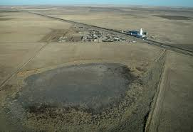
Deflation Hollows
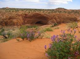
- When deflation causes a shallow depression by persistent movements of wind, they are called as deflation hollows.
- Deflation basins, called blowouts, are hollows formed by the removal of particles by wind.
- Blowouts are generally small, but may be up to several kilometers in diameter.
Mushroom Rock
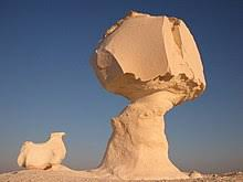
- A mushroom rock, also known as a rock pedestal or pedestal rock, is a naturally occurring rock with a shape resembling a mushroom.
- In desert environments, winds transport a significant amount of sand and rock particles close to the ground, leading to increased erosion at the lower part of the rock compared to the top.
- This differential erosion process results in the formation of rock pillars shaped like mushrooms, characterized by narrow pillars with broad top surfaces.
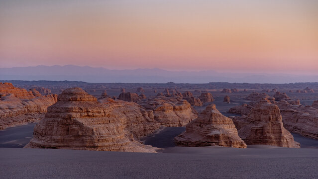
Yardang
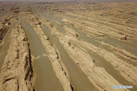
- Yardangs are extensively grooved, fluted, pitted, and irregular rock ridges or reliefs typically ranging from 1 to 10 meters in height.
- They run parallel to the prevailing winds and are formed by differential erosion processes.
- These features are created when sand-laden winds erode zones of softer or weaker rock between harder vertical ridges.
- Yardangs can develop from old lake sediment, where soft, consolidated rock and bedrock surfaces erode into alternating ridges and furrows.
- Large-scale yardangs are notably found in Egypt, particularly near Kom Ombo, north of Lake Aswan.
- They consist of parallel troughs cut into softer rock, running in the direction of the prevailing wind and separated by ridges.
- The direction of the yardangs can serve as an indicator of the prevailing wind direction.
Zeugen
- A Zeugen is a landscape feature comprising alternating horizontal ridges and furrows created by wind abrasion.
- These formations can attain heights of up to 30 meters.
- Zeugens are notable for tabular masses of resilient rock that prominently stand out in desert landscapes.
- They are typically formed from alternating layers of hard and soft rocks, which give them their distinctive appearance and durability.
Playas
- A playa is a flat-bottom depression commonly found in interior desert basins and adjacent to coasts within arid and semiarid regions.
- Periodically, playas are covered by water, which gradually infiltrates into the groundwater system or evaporates into the atmosphere.
- This periodic inundation leads to the deposition of salt, sand, and mud along the bottom and around the edges of the depression.
Depositional Landforms of Wind
Sand dunes
- Dunes are accumulations of loose sand gradually built up by the action of wind.
- They typically consist of quartz, a hard mineral that resists decay.
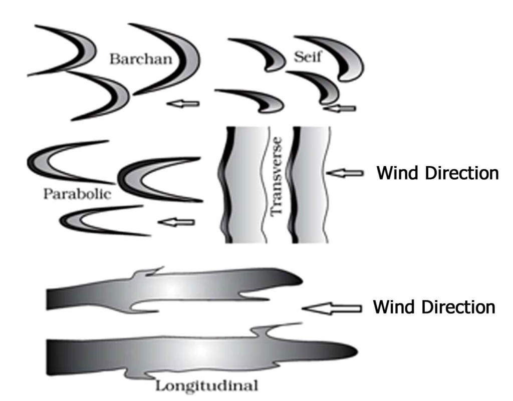
- Among the most common types of dunes are:
- Barchans: These dunes have crescent-shaped points or wings that face away from the wind (downwind). They form in areas with constant wind, where sand moves over a relatively uniform surface.
- Seif: Also known as linear dunes, they are similar to barchans but with a single wing or point.
Loess
- Loess refers to extensive deposits of wind-transported silt that accumulate over thousands of years in various large areas around the world.
- It is primarily composed of windblown silt particles, predominantly made of quartz.
- The formation of loess requires three main factors:
- A source of silt: There must be a plentiful supply of fine silt particles available for transport by wind.
- Wind to transport the silt: Strong and consistent winds are necessary to carry the silt particles over long distances.
- A suitable site for deposition and accumulation: Areas where the wind slows down or changes direction, such as valleys or plains, provide ideal conditions for the settling and accumulation of the silt particles to form loess deposits.
Ripples
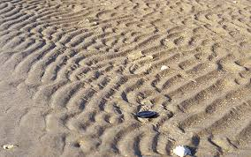
- These features are regular, wavelike undulations oriented at right angles to the prevailing wind direction.
- They are depositional features formed on a small scale.
- Saltation, which involves the transport of hard particles over an uneven surface in a turbulent flow of air or water, is the process responsible for their formation.
Pediplains
When the high relief structures in deserts are reduced to low featureless plains by the activities of wind, they are called as Pediplains.
Waves
Horizontal movement of sea water caused by the wind, rotation of the earth, etc., are called waves.
Action of the Wave
- Coastal erosion is the loss or displacement of land and the long-term removal of sediment and rocks along the coastline.
- It is caused by the action of various factors, including waves, currents, tides, wind-driven water, waterborne ice, and the impacts of storms.
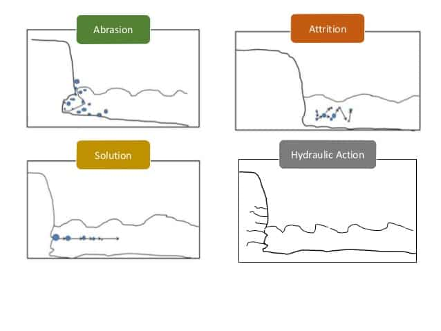
- Waves perform erosive work through the following processes:
- Abrasion: Waves striking the coast with eroded materials cause abrasion, also known as corrasion.
- Hydraulic action: Waves force water and air into rock cracks. When waves retreat, compressed air expands explosively, weakening joints and causing rock to break.
- Corrosion: Waves dissolve soluble rocks, a process termed corrosion or solution.
- Attrition: Eroded materials collide, wearing down into smaller particles, known as attrition.
Landforms by the Erosion of Waves
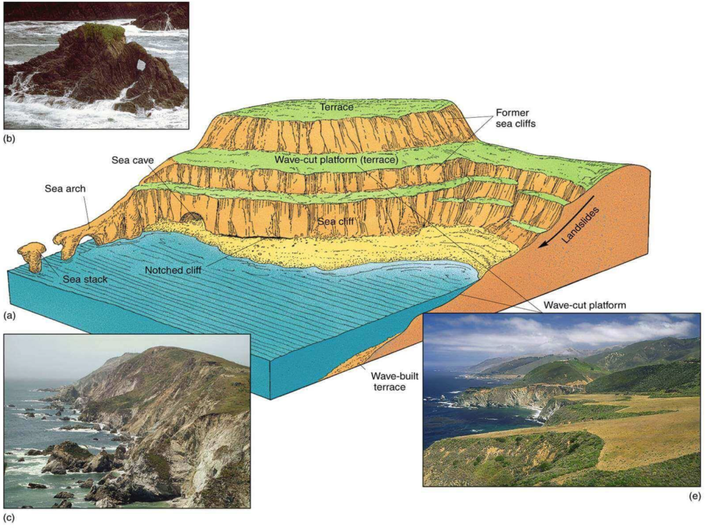
Sea cliff
- Sea cliffs are vertical precipices formed by waves crashing directly onto steeply inclined slopes.
- Hydraulic action, abrasion, and chemical solution cut a notch at the high water level near the cliff’s base.
- Constant undercutting and erosion cause the cliffs to retreat landward over time.
Sea Caves
- Sea caves develop along lines of weakness in cohesive but well-jointed bedrock.
- They are often found in prominent headlands where wave refraction attacks the shore.
Sea Stacks/Skarries/ Chimney Rock
- Sea arches form when sea caves merge from opposite sides of a headland.
- If the arch collapses, a pillar of rock remains behind as a sea stack.
Sea Terraces
- A sea terrace is a rock terrace formed when a sea cliff, with a wave-cut platform before it, is raised above sea level.
Sea Arches
- Arch is formed when the sea cave is cut right through by wave action. The arch is termed as sea tunnel if it is comparatively longer.
- When waves from opposite directions strike a narrow wall of rock, differential erosion of the rock leaves a bridge like structure called Sea arch.
Blowhole or Spouting Horns
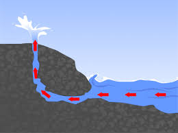
- A blowhole may form in the roof of asea cave by the hydraulic and pneumatic action of waves, with fountains of spray emerging from the top. If blowholes become enlarged, they may collapse.
Chasms
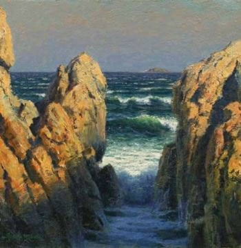
- These are narrow, deep indentations (a deep recess or notch on the edge or surface of something) carved due to headward erosion (downcutting) through vertical planes of weakness in the rocks by wave action.
- With time, further headward erosion is hindered by lateral erosion of chasm mouth, which itself keeps widening till a bay is formed
Hanging Valleys
- If the fluvial erosion of a stream at the shore doesn’t match the retreat of the sea, the rivers appear to be hanging over the sea. These river valleys are called hanging valleys.
Plane of Marine Erosion/Peneplain
- The eroded plain left behind by marine action is called a plain of marine erosion, and if the level difference between this plain and the sea level is not much, the agents of weathering convert it into a peneplain.
Transportation by Sea Waves
- Sea waves, currents, and tides are key agents in transporting eroded material along coastal regions.
- Waves play a particularly significant role in shaping coastal relief features.
- They facilitate transportation in two primary ways:
- Waves remove and transport material deposited by rivers and glaciers from the coast towards the sea.
- They also carry material from the sea to coastal areas, including oceanic items like pearls, conches, and shells.
Deposition by Sea Waves
- Sea waves and oceanic currents aid in the deposition of eroded material from coastal areas.
- Deposition along the coast is selective, with larger particles deposited nearer to the coast.
- Finer particles are deposited further from the coast, as they settle last during transportation.
- However, selective deposition can be influenced by changes in wave intensity or force.
- Occasionally, fine particles can be found near the coast, contrary to the usual pattern of larger particle deposition.
Depositional Landforms By Waves
A number of topographical features are formed due to deposition by waves and currents. Some of these topographical features are discussed here:
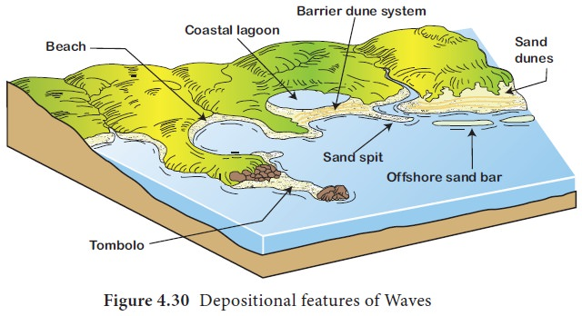
Beach
- Beaches consist of sand and/or shingle and are located in the foreshore and backshore zones.
- Constructive waves deposit material, forming beaches.
- Swash carries material up the beach, while backwash transports some back down, leaving the rest deposited.
- Beaches vary in composition, such as sandy or pebble beaches.
- Sandy beaches often occur in shallow bays with less energetic waves, while pebble beaches form where cliffs erode and waves have higher energy.
- Beach profiles feature ridges known as berms, marking high and storm tides.
- Sandy beaches typically have a gentle slope, whereas shingle beaches can be steeper.
- Larger material is found higher up on the beach due to storm waves, while smaller material is closer to the water, broken down by wave action.
Spits
- Spits are elongated ridges of sand or shingle extending into the sea from a bend in the coastline, typically greater than 30 degrees, yet connected to the land at one end.
- They form on coastlines where there’s a change in direction, such as at a bay or river mouth.
- At the bend, longshore drift continues its original direction but loses energy due to wave refraction and current dispersion, leading to sediment deposition on the seabed.
- With time, accumulated sediment breaks the surface, extending the beach into the sea, forming a spit.
- Spit growth continues until equilibrium is reached at the seaward end, balancing deposition and erosion by waves or river currents.
- The length of the spit is influenced by secondary currents causing erosion, such as river flow or wave action, which can limit its growth.
- At the end of the spit, a hook or recurve may develop.
- This formation occurs due to wave refraction around the distal end, causing sediment transport and deposition in a short distance in the landward direction.
Bar Lagoon and Barrier
- Bars are stretches of sand deposition off the shoreline, with larger forms called barriers.
- They are linear ridges of sand or shingle extending across a bay, connected to land on both sides.
- Bars trap seawater behind them, forming a lagoon.
- Deposits of sand and gravel from waves and currents can also form embankments, separating the shoreline from the sea, creating barriers.
- These deposits, known as sand bars, occasionally create navigation difficulties.
Tombolos
- A Tombolo is a bar that connects an island to the coast.
- Tombolos are linear ridges, or bars, made of sand and shingle.
- They link an offshore island with the coastline of the mainland.
Marine Dunes & Dune Belts
- With the force of on-shore winds, a large amount of coastal sand is driven landwards forming extensive marine dunes that stretch into dune belts.
- Their advance inland may engulf farms, roads & even the entire villages;
- Hence to arrest the migration of dunes, sand binding species of grass & shrubs, such as marram grass & pines are planted.
Terms related to coast
- Sea shore is the zone of land between high tide and low tide.
- Shore line is boundary between land and water.
- Backshore is the beach zone starting from the limit of frequent storm waves to the cliff base.
- Foreshore is the portion of the beach subject to wave action during non-storm conditions.
- Offshore is the shallow zone of the continental shelf.
- Coastline is the boundary where the land meets the sea.
- Swash is the waves washing up thebeach.